
PRODUCTS
GIS FEATURE MAPPING
GIS feature mapping converts airborne LiDAR and aerial imagery datasets into structured spatial data used for infrastructure mapping, municipal GIS systems, and spatial analysis.
OGL performs feature extraction, data structuring, and GIS database development to deliver GIS-ready datasets that integrate directly into platforms such as ArcGIS and QGIS.
Typical deliverables include vector feature classes within geodatabases, supporting asset management, planning, and engineering workflows.
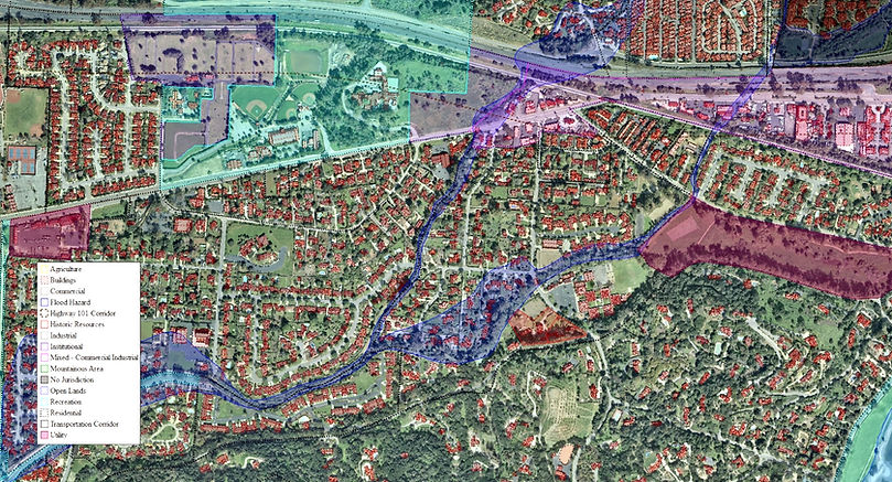
PRODUCTS
FEATURE MAPPING
OGL extracts a wide range of infrastructure and environmental features from LiDAR and imagery datasets to produce structured GIS layers.
Typical Features
-
Building footprints and structures
-
Roads and transportation networks
-
Railway corridors
-
Hydrographic features (rivers, streams, drainage)
-
Vegetation and land cover
-
Infrastructure and corridor assets

PRODUCTS
ATTRIBUTE DATA & GIS STRUCTURING
Mapped features are supported by structured attribute data, enabling analysis, querying, and system integration.
OGL develops datasets aligned with client-specific schemas, ensuring seamless integration into existing GIS environments.
Typical Workflows
-
Attribute creation and population
-
Dataset validation and QA/QC
-
Spatial joins and attribute enrichment
-
Schema standardization

PRODUCTS
GIS INTEGRATION
GIS datasets generated from airborne surveys are designed for integration into municipal and infrastructure GIS systems.
OGL supports projects involving GIS modernization, asset management systems, and ongoing spatial data updates.
Applications
-
Municipal mapping programs
-
Transportation and corridor mapping
-
Infrastructure asset management
-
Environmental monitoring

PRODUCTS
SPATIAL ANALYSIS
Structured GIS datasets enable spatial analysis workflows used in engineering and environmental applications.
Typical Analysis
• Infrastructure proximity analysis
• Corridor and asset analysis
• Terrain-based slope and elevation analysis
• Vegetation proximity analysis for utilities

PRODUCTS
SPECIALIZED FEATURE MAPPING
LiDAR and imagery datasets can be transformed into advanced vector models for engineering and infrastructure applications.
POWERLINE CONDUCTOR MODELLING
-
Vegetation clearance analysis
-
Transmission & Distribution lines inspection
-
Corridor monitoring
-
Asset management
BUILDING MODELS
-
Urban planning
-
Asset inventory
-
Digital twin applications
TRANSPORTATION NETWORKS
-
Roads and railways
-
Corridor planning

HYDROGRAPHIC FEATURES
-
Hydrological analysis
-
Flood modelling